Over what distances do volcanoes interact?

By Juliet Biggs, University of Bristol.

In the geological past, large eruptions have often occurred simultaneously at nearby volcanoes. Now, a team of RiftVolc scientists from the University of Bristol uses satellite imagery to investigate the distances over which restless magmatic plumbing systems interact.

In a study published in the journal Nature Geoscience, the scientists use deformation maps from the Kenyan Rift to monitor pressure changes in a sequence of small magma lenses beneath a single volcano. Importantly, they find that active magma systems were not disturbed beneath neighboring volcanoes less than 15 km away.

The lead author, Dr Juliet Biggs, explained: “Our satellite data shows that unrest in Kenya was restricted to an individual system. Inter-bedded ash layers at these same volcanoes, however, tell us that they have erupted synchronously in the geological past. This was our first hint to compare observations of lateral interactions based on recent geophysical measurements with those from petrological analyses of much older eruptions.

The team, which includes a recently graduated PhD student Elspeth Robertson and Bristol’s Head of Volcanology Prof. Kathy Cashman, took this opportunity to compare observations from around the world with simple scaling laws based on potential interaction mechanisms. They found that stress changes from very large eruptions could influence volcanoes over distances of up to 50 km, but that smaller pressure changes associated with unrest require a different mechanism to explain the interactions.

Prof Cashman explained ‘Volcanology is undergoing a scientific revolution right now – the concept of a large vat of liquid magma beneath a volcano is being replaced by that of a crystalline mush that contains a network of melt or gas lenses. The interactions patterns observed in Kenya support this view, and help to constrain the geometry and location of individual melt and gas lenses.”

The study was funded by two major NERC projects: COMET, a world-leading research centre focusing on tectonic and volcanic processes using Earth observation techniques; and RiftVolc, which is studying the past, present and future behavior of volcanoes in the East African Rift.

The research paper, The lateral extent of volcanic interactions during unrest and eruption, was published online in Nature Geoscience on 15th February 2016, doi:10.1038/ngeo2658

cover

Overlay of satellite radar images of deformation over the Kenya Rift topography, showing Silali (near ground) and Paka volcanoes. Image: Juliet Biggs.


Posted in Uncategorized, geosciences | Tagged , , , , | Leave a comment

Desk Geophysicist in “The Field”

Guest post by Ryan Lloyd, PhD student at the University of Bristol. (Originally posted here).

Last month I returned from the East African Rift: a 4000 km divide between two continents that are slowly moving apart. We were there to visit the Aluto, Corbetti and Bora volcanoes, in Ethiopia.

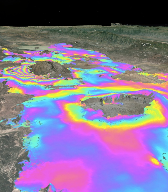
The volcanoes we visited are just three of the over 100 that populate the rift. They are especially important for a number of reasons. Firstly, they allow us to study the continental magmatic behaviour of a fundamental aspect of plate tectonics: divergent plate boundaries. These particular volcanoes are also interesting because of the diverse deformation patterns we have observed using satellites. When volcanoes are seen deforming, it is indicative of a change in volume or pressure beneath the volcano. In many cases, this is associated with an eruption, but, in the Main Ethiopian Rift, no recent eruptions have occurred.

We do not know what is causing the deformation at these volcanoes, and as such, further, field, investigations are necessary. The volcanoes are also sites of rapidly developing hydrothermal energy reserves, and are close to many important population centers.

Our primary aims, therefore, were to collect data that would allow us to  determine how much deformation there has been at each of the volcanoes, and to try to elucidate what might be causing it. To do this we performed dynamic microgravity surveys, which allows us to comment on the mass change beneath the volcanoes since the last visit, and also to service several GPS stations. The GPS on the volcanoes are the same as that in your phone, except we leave them in one particular location for a long time to provide us with an incredibly precise measure of where they are, and how that fixed location may be moving with time.

I wanted to share with you some of the experiences I encountered, and observations I made along the way. The day before I left I confided in my research group that, in truth, I would probably, normally, consider myself a bit of a desk geophysicist. In an attempt to pacify my apprehension they kindly shared some advice, which I gladly pass onto you now:

1. No Slippers
2. No Snakes
3. Probably don’t eat the raw meat
4. Don’t drink the water (or the local home-brews).

Pretty sound advice; to be honest I had never been to sub-Saharan Africa before and had no idea what to expect.

I left for Addis Ababa, Ethiopia’s capital city, on the 23rd September 2015, and arrived safe and sound sometime in 2008… don’t worry, that’s not a typo. Ethiopia works on their own calendar, which is 7 years behind. They also work on “Ethiopian time” which is essentially the same as “European time” but their 1 o’clock is “our” 7am. Of course.

Arriving in Addis, I met Yelebe, our trip leader, and we went for breakfast. I’d been promised, before I left, that Ethiopia has a fantastic food culture, of which they were very proud. I have included some photos of some of my favourite breakfasts for you to at least feast your eyes on.


You’ll notice next to the raw meat the grey flannel. Yeah, that’s not a flannel, that’s injera. Injera is a sourdough made from semi-fermented grass seeds that is eaten with every single meal.  If you go to Ethiopia you will see quite a lot of this stuff. I actually quite liked it. (One word of advice though, you do, however, have to relatively quickly get over the pretty-sure-this-sour-flannel-and-spicy-meat-does-not-go-with-my-toothpaste feeling…).

Addis is actually a fantastic introduction to Africa. It is high enough (2350 m) to be relatively cool, and free of Malaria. It is also a real travel and business hub in East Africa, construction seems to be constantly happening, and the city seemed safe enough such that if I wanted to, I’d have been happy to walk around it on my own (the same was also true for other places we stayed, such as Hawassa).

One of the reasons we were in Addis was to visit the Institute of Geophysics, Space Science and Astrophysics (IGSSA), who are part of the University of Addis Ababa. The IGSSA is where many of the Ethiopian collaborators in RiftVolc work, and having their local knowledge of Ethiopian customs and the volcanoes were imperative, I found, for a successful trip (they also have great coffee there).

I actually also felt exceptionally lucky to be in Ethiopia with the companions I had. The whole time I was with Yelebe, Birhanu (the other field assistant), and Eyaya (our driver), all of whom are Ethiopian. Being with them meant that I got a real feel for Ethiopian culture, and got to see how Ethiopians live their lives in a way that I don’t think you could ever really get as a tourist. I’d just like to take this moment to thank them for their patience in answering my continuous string of questions, and hearing my terrible attempts at speaking Ahmaric. Ah-ma-sa-ga-na-lu!

Being with them as well meant I got to find out what resident Ethiopians discuss over coffee; what bothers them day-to-day. At the moment, for example, many Ethiopians were concerned with the ongoing European migrant crisis. Plenty others had opinions on the new light rail service in Addis that only opened the weekend before I arrived. I also learnt about the local tribal politics, and, for example, their justice system. One thing I really appreciated learning about though, was the actual, physical, on-the-ground considerations required for fieldwork that a desk geophysicist would never even be able to imagine. I learnt about Ethiopia’s history, their religions, traditions, a little Amharic (and thoroughly recommend you do when you visit), and all the things they are proud of. I even know why the man from Jimma would bring coffee to Addis if there were a shortage.

Personally non-geophysical highlights include getting truly defeated at football by small children on the top of Aluto (never was my sport, anyway…). Seeing hippos was good (well, when we actually saw hippos and not just a flock of birds, Eyaya…), as was visiting a Rastafarian Church. I don’t know whether you know anything about Rastafarianism, but I think it’s worth looking up. Actually, strangely enough, the guy who showed us around the church was from Handsworth, an area of Birmingham, just 10 miles from where I grew up. Stranger still, Haile Selassie, Emperor of Ethiopia between 1930 and 1974, and the messiah in Rastafarianism, lived just 10 miles from where I’m sitting right now, in the late 1930’s, in Bath. Small world, eh?

It was also fantastic to be involved in the celebration of Meskel, an Orthodox Christian holiday to celebrate the rediscovery of the cross on which Jesus was crucified. The celebrations generally seemed to involve several really quite large bonfires, coffee and butchering a goat.

SDC15387

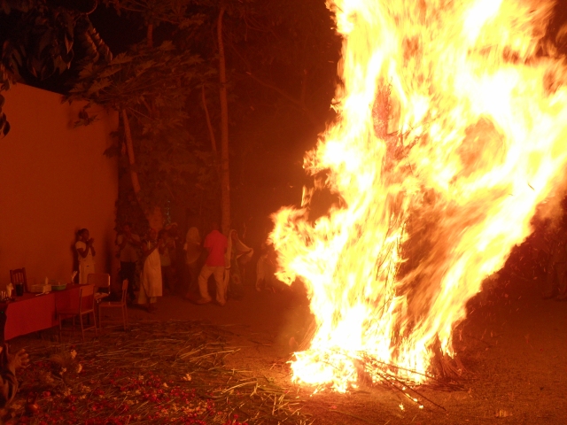
Meskel celebrations at Hotel Bethlehem, Ziway

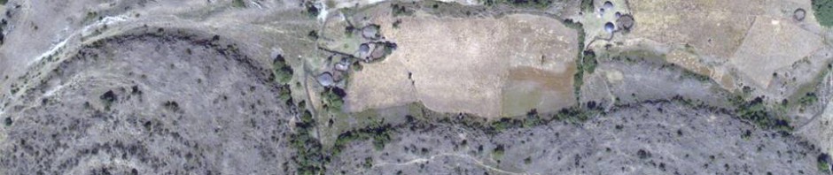
Anyway, despite what this blog so far probably suggests, we did actually do some geophysics. Personally, I was pleased with what we were able to do in the field. It was great to see how GPS stations are deployed; I hadn’t realised how difficult it could be to find a good site for them, for example. A good site requires solid rock for the equipment to be installed on, and also a trusted guard, who lives nearby, and is happy to keep an eye on it. It was also great to go and see with my own eyes what something that has always been a vector on a map of the volcanoes actually looks like in real life.

Left: The gravimeter on Aluto volcano. The gravimeter is the piece of kit that allows us to measure the gravity at a particular location, relative to a base station. Right: Installation of a GPS station near to the rift border faults. It was great to see how much the local villagers (one we befriended was a physics teacher) wanted to be involved, or know more about, the project.

ALUTO_A12G

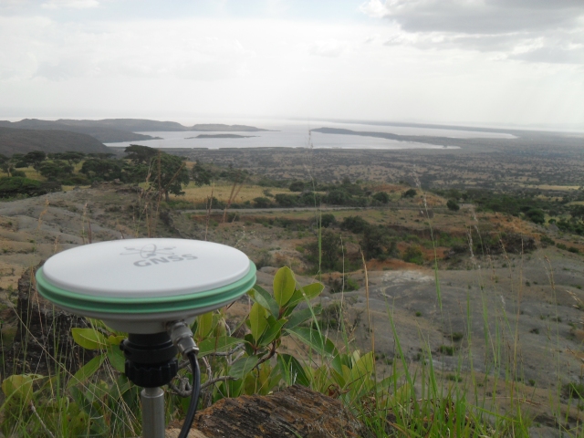
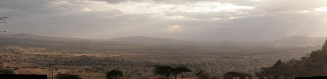
View south from a GPS station on Aluto, across Lake Langano.

The Ethiopia I saw is nothing like the famine stricken picture portrayed by Bob Geldof in the 1980s, which is unfortunately the image that I think many people have of the country. I really encourage you to go, and find out for yourself, as I hope to again.

For now though, I leave an incredibly formative and informative to trip a little less of a desk geophysicist, and a lot more a fan of Ethiopia.

SDC15195

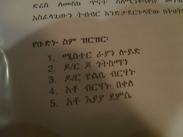
Our crew. No 1 is ‘Mr Ryan Lloyd’ in Amharic

Posted in geosciences, travel, Uncategorized | Tagged , , , , , , | Leave a comment

Volcanoes of the Ethiopian Rift Valley

A blog post from the field, November 2015.

volcanicdegassing

The great Rift Valley of Ethiopia is not only the cradle of humankind, but also the place on Earth where humans have lived with volcanoes, and exploited their resources, for the longest period of time. Perhaps as long ago as 3 Million years, early hominids began to fashion tools from the volcanic rocks from which the Rift Valley was floored, including basalt and obsidian.

IMG_7747_stitch RiftviewView into the Main Ethiopian Rift Valley, on the descent from Butajira to Ziway. Aluto volcano in the centre distance.

The Ethiopian Rift Valley is just one part of the East African Rift system – the largest active continental rift on Earth. While the Ethiopian rift hosts nearly 60 volcanoes that are thought to have erupted in the past 10,000 years, there is only very sparse information about the current status of any of its ‘active’ volcanoes. There are historical records for just two…

View original post 798 more words

Posted in Uncategorized | Leave a comment

PhD Topics in Rift Volcanism for 2015

Map of the Main Ethiopian Rift showing topography, lakes and volcanoes. Key:  Map of the Main Ethiopian Rift (MER) showing topography, lakes (labelled in yellow), volcanoes (red triangles) and centres of population (white stars). Key: NMER - northern sgement of the MER; CMER - central segment; SMER - southern segnment. Lakes (N-S): Ko - Koka; Zw - Ziway; Ln - Langano; Ab - Abiyata; Sh - Shala; Ay - Abaya. Towns/Cities (N-S): AA - Addis Ababa; NZ - Nazret; SH - Shashemene; AW - Awassa. Figure credit: Will Hutchison.

Map of the Main Ethiopian Rift showing topography, lakes and volcanoes. Key:
Map of the Main Ethiopian Rift (MER) showing topography, lakes (labelled in yellow), volcanoes (red triangles) and centres of population (white stars).
Key: NMER – northern sgement of the MER; CMER – central segment; SMER – southern segnment. Lakes (N-S): Ko – Koka; Zw – Ziway; Ln – Langano; Ab – Abiyata; Sh – Shala; Ay – Abaya. Towns/Cities (N-S): AA – Addis Ababa; NZ – Nazret; SH – Shashemene; AW – Awassa. Figure credit: Will Hutchison.

Rift Volcanism: Past, Present, Future is a new 5-year large-scale research project funded by NERC to investigate the volcanism of the Main Ethiopian Rift. The project involves researchers from 6 UK universities (Edinburgh, Bristol, Oxford, Cambridge, Leeds and Southampton), Addis Ababa University, the Geological Survey of Ethiopia and the British Geological Survey. Here are links to a series of PhD topics that are being offered by researchers across the consortium. The funding for these projects will mainly be offered through the appropriate Doctoral Training Partnership – so follow the links to find out how to apply.

Since funding for these projects comes from the UK Natural Environment Research Council, there are quite strict eligibility rules: UK residents should be entitled to full funding; EU nationals who are not UK residents should be entitled to support for fees, but may need additional scholarships to cover living costs; while international students will need to be funded from scholarships or other sources: if in doubt, please ask!.

Bristol (GW4+ Doctoral Training Partnership).  

Monitoring induced seismicity due to geothermal energy production in active volcanic systems.

UK Supervisors: Mike Kendall (Bristol), Richard Luckett (BGS), Juliet Biggs (Bristol), Brian Baptie (BGS)

Cambridge (Fully funded project)

Eruption dynamics of peralkaline rhyolitic volcanism in the Main Ethiopian Rift.

UK Supervisors: Marie Edmonds (Earth Sciences) & Kathy Cashman (University of Bristol)

Edinburgh (Edinburgh E3 Doctoral Training Partnership)

Understanding the nature of pyroclastic density current generation at Quaternary silicic volcanoes in the Main Ethiopian Rift.

UK Supervisors: Eliza Calder (Edinburgh), David Pyle (Oxford), Julia Crummy (British Geological Survey).

Understanding patterns of volcano-tectonic seismicity in active continental rifts (Fully funded project)

Supervisors: Andrew Bell, Ian Main (Edinburgh)

Leeds (Leeds – York Doctoral Training Partnership; fully funded project)

What controls the magmatic plumbing systems of spreading centres in Afar?

UK Supervisors: Tim Wright (SEE), Andy Hooper (SEE), Juliet Biggs (Bristol)

Oxford (Oxford Doctoral Training Partnership in Environmental Research)

Volcanic carbon dioxide emissions in the Main Ethiopian Rift.

UK Supervisors: Tamsin Mather, David Pyle (Oxford)

Understanding volcanism in rift settings: the frequency and magnitude of large explosive eruptions in the Main Ethiopian Rift.

UK Supervisors: Tamsin Mather, David Pyle, Karen Fontijn, Victoria Smith (Oxford)

Southampton (SPITFIRE Doctoral Training Partnership

Interaction between magmatic processes and faulting at an active rift valley volcano

Supervisors: Derek Keir (Southampton), Alex Brisbourne (British Antarctic Survey).

Related links

The RiftVolc project follows on from a number of major research activities in the Ethiopian rift over the past twenty years which have involved collaborators from Ethiopia, Europe and the United States. These include:

Afar Rift Consortium (2007 – 2012) with a focus on the Afar region of northern Ethiopia

EAGLE – the Ethiopian Afar Geoscientific Lithospheric Experiment (2003 – 2007)

 GeoPrisms – East African Rift System Primary Site, a part of the NSF-funded GeoPrisms programme.

Other studentship opportunities

PhD topics related to a NERC-funded ‘Mantle Volatiles’ research theme

The VMSG list of PhD topics in volcanology

Posted in geosciences | Tagged , , , | 1 Comment